Assam GK Section
Districts of Assam
Compiled on 2026-01-18
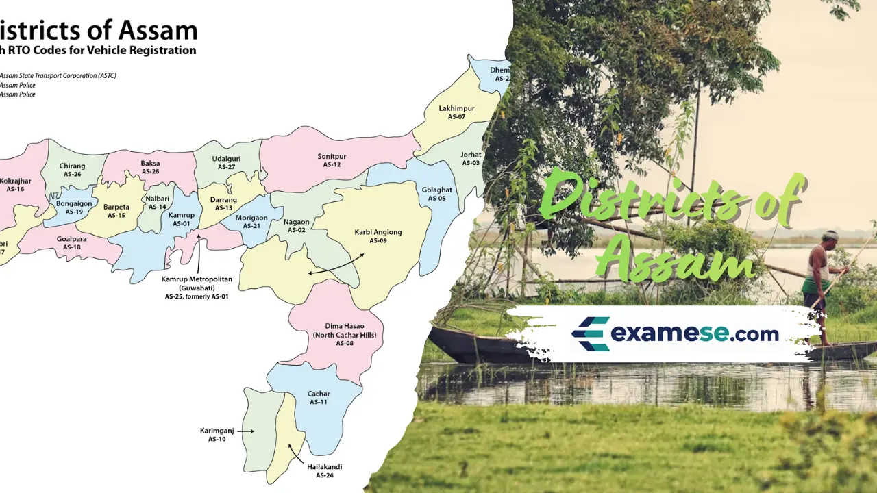
Assam is administered through 35 districts, each led by a Deputy Commissioner who doubles as district magistrate and revenue head.
Key pointers
- District offices coordinate law and order with revenue collection, reflecting the dual role of the Deputy Commissioner.
- Recent reorganisations created Biswanath, Hojai, Bajali and Tamulpur districts in 2015 before temporary mergers in 2022 and restorations in 2023.
- Baksa, Chirang, Kokrajhar and Udalguri fall inside the Bodoland Territorial Area Districts (BTAD), while South Salmara-Mankachar guards the Bangladesh frontier.
- Majuli earned distinct district status for the world's largest river island on the Brahmaputra.
Spotlights
Baksa
- Headquarters at Mushalpur
- Carved out of Nalbari, Barpeta, Kamrup and Darrang
- Borders Bhutan and is predominantly Bodo
Barpeta
- Formed in July 1983 from Kamrup
- Lower Assam district bounded by Bhutan (north), Nalbari (east), Kamrup & Goalpara (south) and Bongaigaon (west)
Bongaigaon
- Headquarters at Bongaigaon town
- Created in 1989 from Goalpara and Kokrajhar
- Sits on north bank of Brahmaputra in western Assam
Cachar
- Southernmost Barak Valley district with HQ at Silchar
- Bounded by the Barail and Jaintia hills, Mizoram and sister districts Hailakandi & Karimganj
Charaideo
- Known for Ahom capital sites and burial mounds
- Hosts Dehing Patkai Wildlife Sanctuary on its slopes
Dhemaji
- North bank district bordered by Arunachal Pradesh
- River Brahmaputra forms southern boundary
Dhubri
- Gateway to western Assam
- Shares borders with West Bengal, Bangladesh, Goalpara, Bongaigaon, Kokrajhar and Meghalaya
Dibrugarh
- Eastern Assam district with HQ at Dibrugarh town
- Brahmaputra flows along the northern edge
Dima Hasao
- Hill district comprising parts of Barail range
- Important rail-road junction connecting Barak and Brahmaputra valleys
Goalpara
- Lies on south bank of Brahmaputra
- Acts as western gateway into lower Assam
Golaghat
- Upper Assam district known for tea, oil and Kaziranga landscape
- Borders Nagaland and the Brahmaputra plain
Hailakandi
- Barak valley district south of Cachar
- Shares boundary with Mizoram
Jorhat
- Cultural capital on south bank of Brahmaputra
- Nearest mainland access to Majuli island
Kamrup
- Encircles Guwahati's rural hinterland
- Bounded by Darrang, Goalpara, Nalbari and Meghalaya
Kamrup Metropolitan
- Urban district centred on Guwahati
- Hosts the state's administrative, commercial and educational hub
Karbi Anglong
- Hill district carved out of the ancient Mikir Hills
- Inhabited largely by Karbi communities with plateau terrain
Karimganj
- Barak valley frontier district
- Shares borders with Cachar, Hailakandi and Bangladesh
Kokrajhar
- Western BTAD district
- International boundary with Bhutan and interstate boundary with West Bengal
Lakhimpur
- North bank agricultural district
- Bounded by Arunachal Pradesh to the north and Subansiri tributaries
Majuli
- World's largest riverine island turned district
- Economy revolves around agriculture and neo-Vaishnavite satras
Morigaon
- Central Brahmaputra valley district with wetlands
- Hosts Pobitora Wildlife Sanctuary
Nagaon
- Central Assam district along the Kolong and Kopili rivers
- Known for agriculture and religious tourism (Bordowa)
Sivasagar
- Former Ahom capital region
- Dotted with historic tanks and temples
Sonitpur
- Largest district before bifurcations
- Borders Arunachal Pradesh and hosts tea belts around Tezpur
South Salmara-Mankachar
- Border district abutting Bangladesh
- Formed from Dhubri's south-western chars
Tinsukia
- Eastern industrial district
- Gateway to Dibru-Saikhowa National Park and oil fields
Udalguri
- BTAD district on north bank
- Known for tea gardens and proximity to Arunachal foothills
West Karbi Anglong
- Western extension of the Karbi plateau
- Forested hills shared with Meghalaya border
Biswanath
- Created in 2015 from Sonitpur subdivisions
- Borders Arunachal Pradesh to the north and Brahmaputra to the south; district status restored in Aug 2023
Hojai
- Formed 15 Aug 2015 from Hojai, Doboka and Lanka tehsils of Nagaon
- Headquarters at Sankardev Nagar; district status reinstated Aug 2023 after a brief 2022 merger
Bajali
- Carved out of Barpeta
- Upgraded from sub-division to district for lower Assam administration
Tamulpur
- Newest BTAD district announced in 2021
- Covers the lower Himalayan foothills between Baksa and Udalguri
Districts of Assam
BaksaBarpetaBongaigaonCacharCharaideoChirangDarrangDhemajiDhubriDibrugarhDima HasaoGoalparaGolaghatHailakandiJorhatKamrup MetropolitanKamrupKarbi AnglongKarimganjKokrajharLakhimpurMajuliMorigaonNagaonNalbariSivasagarSonitpurSouth Salmara-MankacharTinsukiaUdalguriWest Karbi AnglongBiswanathHojaiBajaliTamulpur